Typhoons and Earthquakes in the Philippines
The
Philippines has more than its fair share of disasters, and not because the
country is particularly cursed or anything, but because the entire archipelago—purportedly
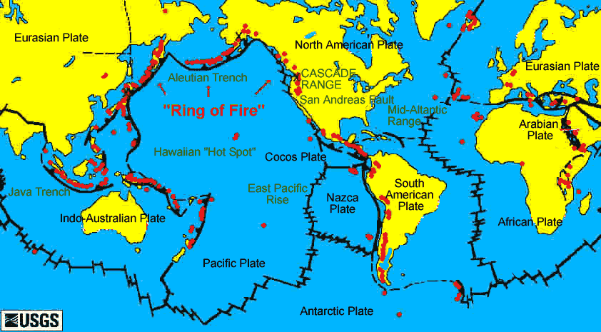
composed of 7,100 islands—lies on a region in the Pacific Ocean called the
“Ring of Fire” (actually, the area is shaped more like a horseshoe, although to
be fair, “The Horseshoe of Fire” doesn’t have the same impact as the “Ring of Fire”).
About 40,000 kilometers long, the “ring” runs from the southern tip of South
America, up along the coast of North America, across the Bering Strait, down
through Japan, the Philippines, Indonesia (the Ring of Fire’s western edge
extends into the Indian Ocean), and to New Zealand. The “Fire” part of the Ring of Fire is because a string of 452 volcanoes dot this line,
like a malevolent game of connect-the-dots.
The
regions along this line experience volcanic eruptions and periodic earthquakes—majority
of them small, hardly-felt tremors, and the few devastating ones that kill
thousands and cause tsunamis that can kill even more.
Besides
being right on the edge of the Ring of Fire, the Philippines is also practically
next door to an area in the Pacific where typhoons regularly spawn.
And,
as luck would have it, the country is right in the typhoons’ path—a sort of
doormat for typhoons as they make their way towards the Asian mainland.

This
means that besides molten rocks and earthquakes, the Philippines also
experiences weapons-grade winds that can tear down homes, uproot trees, cause
storm surges, as well as torrential rains that can trigger flashfloods,
landslides, and destroy crops and properties.
Approximately
80 typhoons develop in this region yearly, and about 19 enter the Philippine
Area of Responsibility (PAR). About six to nine of these typhoons make
landfall, making the Philippines the country most exposed to typhoons.
No
wonder our country is among the world’s most disaster-prone countries.
Right
On Top of Plates
Tectonic
plates, I mean.
These
are part of the Earth’s mantle—massive, irregularly shaped slabs of solid rock
just under the planet’s surface, upon which large section of the Earth rests. They
are called tectonic plates by scientists.
There
are about 8 major plates, and dozens of smaller ones, each carrying a piece of
the world on top, making our planet seem like a gigantic jigsaw puzzle.
Tectonic
plates vary greatly, from a few hundred to thousands of kilometers across. The
Pacific Plate and the Antarctic Plates are the largest. Each plate’s thickness
also varies, ranging from less than 15 kilometers to about 200 kilometers or
more. The plates constitute the lithosphere, which is a layer of rock on the
top of the Earth’s mantle.

Beneath
the lithosphere is a partially molten rock layer called asthenosphere. Driven by
forces from deep beneath the earth, the plates slowly move across the planet’s
surface, interacting with other plates, diverging, colliding, and slipping past
each other. The edges of these plates, where they bump and grind against other
plates, are the sites where earthquakes commonly happen, and where many
volcanoes are active.
These
movements also influence the form of the planet’s surface. Where the plates
meet, mountain-building occurs—besides earthquakes, volcanic activity, and
oceanic trench formation.
According
to the plate tectonics theory, Earth’s outer shell is divided into several
plates that glide over the rocky inner layer above the core called the mantle. Actually
a modern version of Alfred Wegener’s Continental Drift Theory first proposed
in 1912, this theory explains how the Earth’s continents move around the
planet. Tectonic plates probably developed very early in the Earth’s
4.6-billion-year history. They have been drifting since, pressing against each
other, then separating again, like some fiery and explosive dance that has been
going on since the beginning of time, in the process forming and shaping the
world as we know it.
The
plates move about the same rate as the growth of your fingernails, so the world
that we know today is different from what it was millions and millions of years
ago. And millions and millions of years from now, the world will wear a face
unrecognizable to us.
Most
of the boundaries between individual plates are hidden beneath the oceans, so
they cannot be seen. They can be accurately mapped, however, from outer space
by measurements from satellites.
Plates
change over time, like many features on the surface of the Earth. Plates that
are composed of denser materials, like an oceanic lithosphere, can sink under a
lighter continental plate, and can eventually disappear completely. There are actually
plates that are in danger of disappearing.
The
Philippines, as we have mentioned, is in the Pacific Ring of Fire, where the oceanic
Philippine Plate and a few much smaller plates are subducting, or sliding
under, along the Philippine Trench. Moreover, scientists consider the
Philippine Sea plate as unusual, because almost all the boundaries of the
surrounding plates are converging.
This
means that the country is being squeezed by two large tectonic plates—the
Pacific Plate and the Eurasian Plate.
Note: This is an excerpt from my forthcoming book, "Disaster Management for Filipinos"


Comments
Post a Comment
So, what do you think? Post it here: